Subdivision Plat Approval or Amendment
Application Checklist:
A subdivision application is needed to subdivide unplatted land, or to replat previously platted land.
Applications to divide land into 4 or fewer parcels, or applications to adjust a boundary line without creating or eliminating any parcels, can follow either the Minor Subdivision process or the Boundary Line Adjustment process. All other subdivisions follow the Preliminary Plat Process and Final Plat Process described here. See UDC Section 50-33 and Section 50‐37.4 for more information.
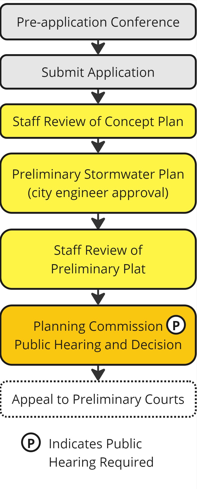
Starting the Application Process
Call 218‐730‐5580, email planning@duluthmn.gov or visit www.duluthmn.gov/eplace to request a pre‐application meeting. The pre‐application meeting is intended to discuss the application process and general timeline. A comprehensive review of the proposed project is not possible at this meeting; detailed review of the project will occur once a complete application, with sufficient supporting information and exhibits, is submitted.
Concept Plan
The concept plan may suggest potential street names, but the City has the final authority in assigning new street names. Read and review the requirements of 50‐23 Connectivity and Circulation, and 50‐33 Plats, before submitting a concept plan.
Submit your concept plan:
- Visit www.duluthmn.gov/eplace to submit your application.
- Click on “Apply” and search for your application type. (You will need to sign in to the system, or create a new account if you do not already have one.)
- Follow the prompts to fill in information. Required information is indicated with an asterisk.
- On the attachments page, upload the following:
- Exhibit showing the current property/lot line configuration
- Exhibit showing the proposed property/lot configuration (including proposed public right of way or utility/pedestrian easements)
- Exhibit showing site characteristics such as water features including wetlands, dense tree stands, rock outcroppings, etc.
- After your application is complete, click “Add to Cart” for the fee listed, and pay the fee. Applications without a fee will not be accepted or reviewed.
Planning Staff, in conjunction with staff from Engineering and Fire (and any other appropriate City or public agency) will review the concept plan. An action letter with a list of comments and changes will be sent to the project applicant.
Preliminary Storm Water Plan
Submit a Preliminary Storm Water Plan to City Engineering (see UDC Section 50‐33.2.B); this is required before a preliminary plat is submitted for Planning Commission review. The Engineering office will issue a letter with any comments on this preliminary plan.
Preliminary Plat Process
After receiving comments about your concept plan, make any necessary changes to the proposal. Submit your application materials by the Planning Commission application deadline.
- Visit www.duluthmn.gov/eplace to submit your application.
- Click on “Apply” and search for your application type. (You will need to sign in to the system, or create a new account if you do not already have one.)
- Follow the prompts to fill in information. Required information is indicated with an asterisk.
- On the attachments page, upload the following; all items should be readable when printed on an 8.5"x11" page:
- Legal description in recordable form
- Property boundary survey
- A vicinity map (8.5” x 11”) indicating the site and names of adjacent streets
- A utility plan showing the location of proposed water, sewer, and storm water drainage facilities necessary to serve the platted area and connections to the surrounding area
- A preliminary plat, prepared at a scale of no less than 1”=100’, and at a scale sufficient to clearly show the following details:
- The proposed name of the subdivision
- The location and boundaries of the subdivision, names of all abutting subdivisions with lines indicating abutting lots, or, if the abutting land is unplatted, a notation to that effect, and names of all abutting streets
- Contours at two‐foot intervals
- The date of preparation, scale, and north sign
- The location of structures on the property and approximate location of structures off the property within ten feet of the proposed plat boundary
- The name, address, and telephone number of the licensed surveyor, licensed engineer, or designer of the plat
- Total acreage, total linear feet at the subdivision perimeter, and, if the subdivision is in an R‐C, RR‐1, or RR‐2 district, the total linear feet around building lot clusters
- The location and dimensions of all proposed public improvements, public easements, lot lines, parks, and other areas to be dedicated for public use and identification of areas reserved for future public acquisition
- Zoning on and adjacent to the proposed subdivision, including shoreland areas, Skyline Parkway Overlay areas, and shore and bluff impact zones
- Areas subject to the one‐hundred year flood, base flood elevation data, and the source used in determining that elevation
- A designation of all wetlands by type
- Location of wildlife areas, rock outcrops, tree stands and areas in their natural state that are unsuitable for development
- Names of all proposed and existing streets
- Radii on all street curves
- The location and size of existing utilities within or adjacent to the proposed subdivision including water, sewer, storm sewers and drainage facilities, fire hydrants within three hundred fifty feet of the property, electricity, and gas
- Wetland delineation report, if required
- Tree Preservation Report and Tree Replacement Plan, if required
- After your application is complete, click “Add to Cart” for the fee listed, and pay the fee. Applications without a fee will not be reviewed or accepted.
After Submitting Your Application
- Determination of Completeness. Within 15 business days of your application, you should expect to:
- Receive an “Applicant Letter,” which acknowledges a complete application, shares the date of the Planning Commission meeting and the assigned staff person, and notifies you of State‐mandated deadlines for the City to make a decision, OR
- Receive notification that your application is incomplete, with details on further information to submit.
- Public Notice.
- You are required to post a sign notice on the property at least two weeks before the date of the public hearing. See UDC Section 50‐37.1.H for information on size, placement, and content of each sign; you may want to contact a sign company or printing company to have the sign made. You must provide evidence that the signs were in place; submit photo(s) of the signs to the Planning Division at least two weeks before the date of the public hearing.
- Staff Review.
- Planning staff will evaluate your application and prepare a staff report. When considering a recommendation for Planning Review, Planning Staff generally review the zoning of the site (including overlay zones), the Comprehensive Plan (including the Future Land Use Map, Governing Principles, and Policies), surrounding land uses and zoning, individual factors that are unique or special to the proposal, any additional UDC criteria, and other related factors.
- You will receive an email with the Planning Commission agenda and a link to the staff report about 5 days prior to the meeting.
- Planning Commission Hearing.
- Planning Commission meetings are scheduled at 5:00 pm on the second Tuesday of each month. We ask that applicants or an agent attend this meeting. Planning Commission will hold a public hearing and make a recommendation to adopt, adopt with modifications, or deny the application.
- You will receive an Action Letter documenting the decision.
Preliminary Plat Process
After receiving comments about your preliminary plat, make any necessary changes to the proposal. Submit your application materials by the Planning Commission application deadline.
- Visit www.duluthmn.gov/eplace to submit your application.
- Click on “Apply” and search for your application type. (You will need to sign in to the system, or create a new account if you do not already have one.)
- Follow the prompts to fill in information. Required information is indicated with an asterisk.
- On the attachments page, upload the following; all items should be readable when printed on an 8.5"x11" page:
- Legal description in recordable form (consult a surveyor or attorney if needed)
- A vicinity map indicating the site and names of adjacent streets
- Final plat at a scale no less than 1”=100’, and at a scale sufficient to clearly show the following details. Note that MS 505.021 is included in the appendix for your reference.
- The subdivision title (must meet MS 505.021 Subd. 5)
- Accurate dimensions (meeting MS 505.021 Subd. 5) for all lines, angles, and curves used to describe boundaries, public improvements, easements, areas to be reserved for public use, and other important features. All curves shall be circular arcs and shall be defined by the radius, central angle tangent, arc and cord distances. All dimensions, both linear and angular, are to be determined by an accurate survey.
- The names of all abutting subdivisions, or if the abutting land is unplatted, a notation to that effect.
- An identification system for all lots and blocks (must meet MS 505.021 Subd. 4) and names of streets (must meet MS 505.021 Subd. 6)
- The location and dimensions of all proposed public improvements, public easements, lot lines, parks, and other areas to be dedicated for public use and identification of areas reserved for future public acquisition
- Total acreage, total linear feet at the subdivision perimeter, and, if the subdivision is in an R‐C, RR‐1, or RR‐2 district, the total linear feet around building lot clusters
- The number of lots and each lot size
- Ownership and use of outlots
- Areas subject to the one‐hundred year flood, base flood elevation data, and the source used in determining that elevation
- Certifications by the land surveyor, local government official, county surveyor, county tax official, and county recorder, as specified in MS 505.021 Subd. 9.
- A survey as specified in MS 505.021 Subd. 10.
- Tree Preservation Report and Tree Replacement Plan, if required
- Two copies of documents granting any easements required as part of plat approval (if applicable). The county clerk and recorder’s recording number and proof of ownership of the property underlying the easement must be satisfactory to the city attorney.
- If wetlands are being impacted, a copy of the approved Notice of Decision for the wetland replacement plan.
- After your application is complete, click “Add to Cart” for the fee listed, and pay the fee. Applications without a fee will not be reviewed or accepted.
After Submitting Your Application
- Determination of Completeness. Within 15 business days of your application, you should expect to:
- Receive an “Applicant Letter,” which acknowledges a complete application, shares the date of the Planning Commission meeting and the assigned staff person, and notifies you of State‐mandated deadlines for the City to make a decision, OR
- Receive notification that your application is incomplete, with details on further information to submit.
- Staff Review.
- Planning staff will evaluate your application and prepare a staff report. When considering a recommendation for a subdivision plat approval or amendment, Planning Staff generally review the Comprehensive Plan (including the Future Land Use Map, Governing Principles, and Policies), criteria listed in the UDC, surrounding land uses and zoning, consistency with any approved district plan, adequacy of infrastructure and public safety capacity to service the proposed plat, individual factors that are unique or special to the proposal, and other related factors.
- You will receive an email with the Planning Commission agenda and a link to the staff report about 5 days prior to the meeting.
- Planning Commission Hearing.
- Planning Commission meetings are scheduled at 5:00 pm on the second Tuesday of each month. We ask that applicants or an agent attend this meeting. Planning Commission will hold a public hearing and make a recommendation to adopt, adopt with modifications, or deny the application.
- You will receive an Action Letter documenting the decision.
- Recording (if approved).
- Record the final plat in the office of the county recorder within two years after approval.
- The plat will need signatures from the President and Secretary of the Planning Commission prior to recording; contact your assigned staff person to coordinate these signatures.
- Submit a receipt or other documentation that it has been recorded to the City’s One Stop Shop.
- After the final plat has been recorded, lots may be sold and building permits may be issued. Building permits cannot be issued until the City has received documentation of the subdivision being recorded with the county recorder.
- If applicable, file a recorded copy of applicable Home Owner’ Association (HOA) bylaws and regulations to the One Stop Shop.
- The City of Duluth will require two mylar copies of the final plat.
- Record the final plat in the office of the county recorder within two years after approval.
Note that other City codes may apply to your project. Please be aware of any applicable Building Code (Construction Services Division), Fire Code (Life Safety Division), and stormwater/engineering (Engineering Division) regulations. The zoning approval may be only the first step in a several step process.
If a wetland delineation is needed for the project to proceed, it must be reviewed and approved before any zoning application will be accepted. If a wetland replacement plan is required for a project to proceed, it must have been submitted and accepted as a complete application before the project zoning application will be accepted.